| ||||
For directions to the Shuttle Drop Points click the Sheep Creek or Stein Mountain Waypoints. Sheep Creek Road opens up sometime in May and Stein Mountain is often not open until mid-July.
There were USFS crews diligently working on the trails in Wagonhammer during the summer of 2010. They did an amazing job and the trails are in great shape. Nothing is signed yet, however, so watch for other tire tracks, follow the maps and use your GPS.
Please Close ALL Gates between June 1 and Sept 1. We share Wagonhammer! Be a good steward.
Elk Trail Loop:
9.0 miles. Singletrack. 1675' Up and Down. High 5100' and Low 3850'.
|
Burns Gulch Loop:
8.2 miles. Singletrack. 1750' Up and Down. High 5200' and Low 3650'.
|
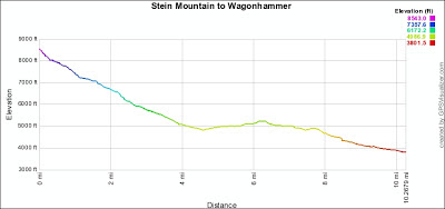
Wagonhammer - Shuttle:
10.3 miles from Stein Mountain. Singletrack. 510' Up. 5140' Down.
8.1 miles from Sheep Creek Road. Singletrack. 460' Up. 2840' Down.
A note: The lower end of Big Silver Lead Trail is private. Get permission of don't go.
|
Carl Gulch - Shuttle:
8.2 miles from Stein Mountain. Singletrack. 730' Up. 4650' Down.
3.6 miles from Sheep Creek Road. Singletrack. 460' Up. 2230' Down.
|
Trail Gulch - Shuttle:
8.7 miles from Stein Mountain. Singletrack. 900' Up. 5010' Down.
4.1 miles from Sheep Creek Road. Singletrack. 610' Up. 2580' Down.
|
Burns Gulch - Shuttle:
10.0 miles. Singletrack. 560' Up. 5140' Down.
|
|
|
|
|
|
This page and map were updated Dec 2017; TrailForks map fix.


