Idaho Parks and Rec have recently improved their website to include an
interactive map of the entire State of Idaho. This is an interactive map of
every official road and trail in the state! It is so handy that this site earned a permanent spot on the right hand side of this page--->
Here a statement from their
Trail Mapping Program page...
Where can I get a map of the Non-Motorized trails in Idaho?
That’s the question our customers ask most often, and now we have an
answer. The Idaho Department of Parks and Recreation is excited to
announce its new online, trail mapping application. Our new site will
provide a one-stop shop for trail maps. It covers all riding areas
across the State and is readily available to you. When you get to the
site, just look for trails that are marked with Red Dashed Triangles.
Trail enthusiasts can now go online and browse the entire State of
Idaho. Once you’ve selected your riding area, you can print a map at
home or download the file and take it to a third party to be printed at a
larger scale. Another really exciting feature is being able to export
your newly created trail map into Google Earth. From there, all of the
popular Google Earth tools are available such as viewing in 3D and
changing the orientation of the map.
This project was completed using OHV registration fees.
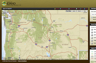
What looks like a basic map of Idaho...
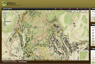
...quickly becomes much more after zooming in a couple clicks on the Zoom Tool. Every road, every double-track, every trail shows up in a web.
Before zooming any further it is time to point out several very handy tools. These tools have become a necessity for Mtn Bike rides around here, especially if we are exploring areas new to us.
- Trail Search
- Route Category
- Export to...
- Distance

The
Trail Search and the
Route Category tools are to the right of the map. The
Trail Search
is used, obviously, by typing in the name of the area you are looking
for. This tool works well and has two options; "search all of Idaho",
and "search viewable area". After entering the search term a list of
results comes up. Click on one of those and the Map automatically zooms
to that feature and highlights it if it is a Route. There is a Blue
arrow in the upper right portion of the search pane that clears the
results and takes you back to a blank form. Common names or official
route designation numbers used by BLM and USFS come up in the results.
The route #s are current with the latest maps and travel plans.
A Route will also be highlighted on the map just by clicking on it. Route information will be shown in the panel to the right of the map. Links for Driving Directions and Idaho Road Report are conveniently placed at the top under the Route Name. The official Route number and the length of the segment are listed. A photo showing the main type of travel and icons showing what type of travel is allowed appear. Seasonal Access Information and local contact information, including links, also appear. Even Weather for that area comes up. The Parks and Rec folks thought of everything!
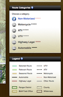
The
Route Category tool has a hidden and not so obvious feature. Mousing over the types of travel in the list highlights them Blue. Clicking a type of travel will highlight that mode of travel in the tool bar and also highlight routes on the map according to the Legend below the tool. So after you have Searched and zoomed to that area, you can use this tool to see what types of travel are or are not possible there.
The Legend gives colors to the "Selected Route" and "Relevant Route" on the map. This shows, for example, where you can travel legally on an ATV and also where you must stop.
Now that you have found the Route you would like to travel on, the Toolbar at the top of the map has a couple more great tools. Once a Route is selected and highlighted you can
Export to GPS. A GPX file is created and uploaded to your computer for you to save and upload to your GPS. The upper toolbar also has
Print and
Export to Google tools which perform obvious functions.

The
Distance Tool at the left of the upper toolbar list is very handy. Clicking this tool activates the Distance Mode for the map. Now you can click on the map to place navigation waypoints. Place as many waypoints as you want and mouse-over and drag the route to new roads as needed. Much like the Driving Directions on common online mapping websites like GoogleMap.
A list appears on the right of the map giving the total distance, route names and numbers between each waypoint. Distances traveled on specific portions of the selected route are given and a subtotal of the distance for that segment between waypoints. Icons for legal modes of travel on each portion are also shown.
You can now download this entire route to GPX for later upload to your GPS unit. Each leg will be named appropriately on your GPS unit.
How great is this tool for putting together big backcountry rides? Hopefully Park and Rec Departments in other states do the same. Thanks OHV license payers!!
It should be noted that these saved GPX downloads will not be opened directly by Garmin BaseCamp. They open fine with other mapping softwares however, and when re-exported as the same GPX, BaseCamp opens the files perfectly. Perhaps this is an issue only on the Apple OSX version of BaseCamp?


