| ||||

More specific ride details are below the map.
Water is available at Williams Day Use Area. Camping is available at Cougar Point a mile or so above the Williams Day Use Area. There is a nominal fee to camp at Cougar Point and there are 12 sites.
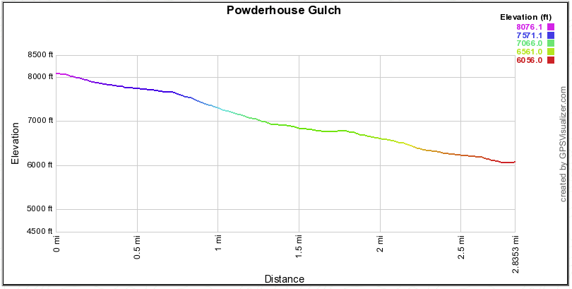
Powderhouse Gulch - Shuttle:
3.0 miles. Singletrack. 40' Up. 2000' Down. High 8100' and Low 6070'.
Straight at the Pond and across the log bridge there is the most common way of riding this.
Option 1: Taking a right at the Pond is the Powderhouse Meadow Option. This variation is 3.5 miles and 2380' Down.
Option 2: Extend a Powderhouse Shuttle by adding the Lower Williams Trail. Check the next trail listed below for this one.
|  |
Powderhouse Plus Perreau - Shuttle:
11.9 miles. Singletrack and gravel road. 820' Up. 4680' Down. High 8100' and Low 4500'.
|  |
North Moccasin - Shuttle:
3.0 miles. Singletrack. 140' Up. 1380' Down. High 6180' and Low 6880'.
Options: Take a left at the junction at the upper end of the meadows for the North Moccasin Cutoff. This trail adds a mile of distance and is a fun singletrack variation.
|  |
Lower Williams aka Perreau Trail - Shuttle:
7.4 miles. Singletrack. 760' Up. 2470' Down. High 6500' and Low 4300'.
|  |
In addition to these popular rides here are a few others...
Phelan Mountain Road is a great out and back on an old, smooth, overgrown USFS roadbed.
Several loops can be had on the Williams XC Ski Trails. Most of these have good singletrack, if not follow the Blue Diamonds on the trees. Meadow to Powderhouse Loop. Meadow to Buckhorn to Williams Creek Trail. Perreau Meadows is great singletrack and easily added to the above mentioned loops.
Mukluk is a fun downhill but you will need to do some navigating for the first couple miles.
- <GPX Download of Williams XC Trails> (Rt. Click-Save As)
This page and maps were updated Dec 2017; TForks widget tweaks, conditions button.